Real-Time Emergency Room Congestion Map
Launch Emergency Room Congestion Map ↗
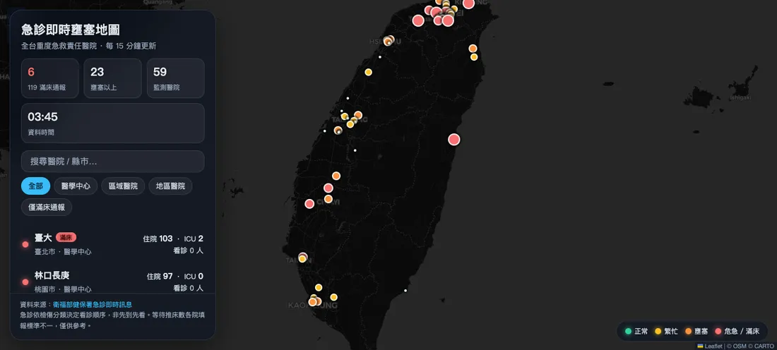
A real-time emergency department congestion tracker monitoring 59 tertiary emergency hospitals across Taiwan. Powered by real-time open-data APIs from the National Health Insurance Administration under the Ministry of Health and Welfare—entirely free, registration-free, and refreshed every 15 minutes. Before rushing to the ER, check where wait times are longest.
Feature Highlights
- Congestion Tier Badges — Four-stage color-coded radar indicators (Normal → Busy → Congested → Critical), with pulsing animations highlighting hospitals reporting full bed capacity to emergency dispatch (119)
- Live Metrics Dashboard — Real-time tracking per facility: patients waiting for initial consultation, pending inpatient admission, awaiting ICU beds, and waiting on transfer gurneys
- Search & Filtering — Search by hospital name or administrative region; filter by hospital accreditation tier (Medical Centers / Regional Hospitals / District Hospitals / Full Bed Alerts Only)
- Google Maps Navigation Integration — Click any facility popup to trigger turn-by-turn navigation directly
- Fully Automated Data Pipeline — Scheduled GitHub Actions workflow polls the NHI API every 5 minutes; frontend automatically re-fetches snapshots every 5 minutes
- Dark Glass Interface — Dark glassmorphism UI paired with an optimized mobile bottom drawer
Technical Architecture
er-map/
├── src/
│   ├── main.js      # Leaflet map logic
│   └── style.css    # Dark glass theme
├── scripts/
│   ├── geocode-hospitals.mjs  # One-time OSM Nominatim geocoding
│   └── fetch-data.mjs         # NHI API → static JSON
├── data/hospitals.json        # 59 hospital coordinates (static)
├── public/data/er-status.json # Live data snapshot (CI updated)
└── .github/workflows/
    └── fetch-data.yml         # 5-minute cron
Vite + Leaflet + CARTO Dark basemap, fully static and hosted on Cloudflare Pages without backend compute. Live telemetry is distributed via GitHub raw CDN, updating status without triggering Pages rebuilds.
Data Sources
Hospital coordinates resolved via one-time geocoding through OpenStreetMap Nominatim.
Have a similar project in mind?
Tell me the purpose and direction, and we will find the right approach together.